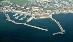
Anstruther Harbour
Telephone: 03451 555555 ext 461541
Email: Contact by email
Opening times
Mon - Fri 0900 to 1700 hours Sat/Sun 0900 to 1200 hours (April to Sept)
Resources
- Shower
- Disabled Toilets
- Public Toilets

Lead Harbour Master | Allan Anderson |
---|---|
Harbour Master | N/A |
Website: | www.fife.gov.uk |
Email: | Harbours@Fife.gov.uk |
Telephone: | 03451 555555 Ext 461541 |
Out of Hours: | 03451 55 00 99 |
Address: | Shore Street, Anstruther, KY10 3AQ |
Description | The harbour has two basins and four piers. The East Basin, exposed to wave action especially in winter, is not used for permanent year-round mooring but accommodates creel boats and other vessels for short stays. The West Basin hosts permanent recreational craft, creel fishing boats, and commercial vessels. Anstruther Wester Pier is a historic pier and has no current use by any vessels. | ||||
---|---|---|---|---|---|
Location | Northern shore of the Firth of Forth | Imray chart No | C27 | ||
Limits | The harbour limits are outlined in the Schedule to the Fife Council Harbours Byelaws 1996, broadly extend as follows:
| ||||
Approach | The harbour is open from the southeast to the southwest. The entrance is shallow, especially at low tide, with shoals and rocks extending from the West Pier. The East Pier has a red beacon pole with a flashing green light, while the West Pier has an unlit white lighthouse and a grey post with two fixed red lights. White leading poles at the rear of the East Basin provide a leading transit of 019° with fixed green lights at night. | ||||
Usage | Fishing vessels. Commercial vessels | ||||
Latitude (Entrance) | 56.221071N | Longitude (Entrance) | 2.697948W | Grid Reference | 356817,703386 |
Tidal Range | 0.1 to 5.9 m (Chart Datum) | Neap Tide | 2.2 m | Spring Tide | 4.5 m |
Navigational Access | Leading Lights/Poles | Tide Gauge | No | Berths | 100 Pontoons |
Tugs | No | Anchorage | No | Pilotage | No |
Cargo Handling | No | Repair facilities | Drying Beach | ISPS Compliant | N/A |
Maximum Draft | 2.4 m | Maximum Length | 11 m | Maximum Beam | 8 m |
Control Depths/Drafts | Location | Bed Material | Bed Level | Keel Clearance | Note |
---|---|---|---|---|---|
Harbour Mouth along West Pier | Sand / Silt | 0.6 to 1.2 m | Min 1 m | Prone to Silting | |
East Basin | Sand / Silt | 0.6 to 2.0 m | N/A | Restricted Mooring | |
West Basin (W) | Sand / Silt | 0.9 to 1.8 m | N/A | Prone to Silting | |
West Basin (W) | Sand / Silt | 1.2 to 1.8 m | N/A | Prone to Silting |
Communication | VHF | Calling and | 16 | Harbour Operations | 11 |
---|
Operating Constraints | In high winds and / or large easterly swells the approach to the entrance channel can be very difficult and the Harbour Master's advice must be sought prior to arrival or departure |
---|---|
In restricted visibility, the Harbour Master will determine whether vessels can safely leave or enter | |
The approach to the harbour entrance is relatively shallow, particularly around low water, and the seabed shoals to the west, where there are also rocks running out from the West Pier | |
The entrance into the harbour is around 40m in width, but the entrance into the west basin is much narrower at around 11m in width | |
Both the east and west basins dry out completely at low spring tides right up to the harbour mouth, but both basins have a sandy bed | |
If mooring on the pontoons, access is controlled by a fob-operated security gate system. Permanent berth holders and visitors can obtain fobs from the Harbour Master. Visitors should arrange in advance with the Harbour Master to collect a fob for their stay. An emergency exit button is located next to each security gate, allowing visitors to exit the pontoon system. |
Aids to Navigation | 2 FR vert 5m 4M - West Pier Head (Grey Post) |
---|---|
Fl G 3s 6m 4M - East Pier Head (Red Beacon Pole) | |
F G 7m 4M - Front Leading Light (White Marker Board on Pole) (Leading Line 019°) | |
F G 11m 4M - Rear Leading Light (White Marker Board on Pole) (Leading Line 019°) |
Environmental Sensitivity | Special Area of Conservation (SAC), Special Site of Scientific Interest (SSSI), |
---|
Oil Pollution Hazard | Responsibility | Control | ||
---|---|---|---|---|
General Oil Spillage | Fife Council | Provision of signage stating the organisations to be contacted in the event of an oil spillage when the Harbour Master is not on duty – maximum response time 90 minutes | ||
Competent trained operatives including accredited to MCA1 and or MCA4 Oil spill response | ||||
Provision and storage of Tier 1 oil pollution clean-up and containment materials | ||||
Equipment | Number | |||
3m x 13cm Spaghetti Water Boom | 10 | |||
50cm x 40cm Absorbent Pads | 50 | |||
Protective Chemical Suit | 1 | |||
Provision for Tier 2 Specialist Contractor | ||||
Oil Pollution Action | Contact Fife Council immediately Fife Council will implement the Oil Pollution Response Procedure to effectively manage and mitigate the impact of oil pollution incidents. |